Altimetry Products
Products Overview
There are different data products associated with the three levels of processing of Sentinel-3 Surface Topography Mission (STM) data:
Level-0 product is the raw telemetry data.
Level-1 product is the Level-0 product corrected for instrumental effects.
Level-2 product is the Level-1 product, delay-Doppler processed and retracked, corrected for geophysical effects.
SRAL Level-0 scientific products, SRAL Level-1 scientific products, SRAL calibration products (SR_0_CAL and SR_1_CAL) and MWR products (MW_0_MWR, MW_1_MWR and MW_1_CAL), are not available to users and are considered only as an input to processing chains.
SRAL Level-2 products are available to users.
ESA and the Sentinel-3 Mission Performance Cluster (MPC) have developed in 2021-2022 dedicated delay-Doppler (Unfocused SAR) and Level-2 processing chains for the generation of new Sentinel-3 STM LAND level-2 products over inland waters, sea-ice, and land ice areas. The main objective of these so-called “Thematic Products” is to address the specific needs of the user communities related to the three different Thematic surfaces. The Baseline Collection (BC) of these new Thematic products is 005 (BC-005). These official so-called “Hydro-Cryo” L2 products are operationally produced from the 20th of October 2023 and replace the land product generated with the BC-004.
SRAL Products Levels
SRAL data products associated with the three processing levels are listed below:
Level 0 product (SR_0_SRA) output by the Level-0 processing and not distributed to users: it consists of time sorted and annotated data from Instrument Source Packets (ISP).
The product types disseminated to users (except for SR_1_LAN_RD) are:
Four types of Level-1 products:
Level-1A products (SR_1_SRA_A): geo-located bursts of echoes with all calibrations applied. These are given in input to the delay-Doppler (Unfocused SAR) processor.
Level-1B products (SR_1_SRA): geo-located, fully calibrated & multi-looked High Resolution power echoes (L1B SAR waveforms).
Level-1B-S products (SR_1_SRA_BS): Unfocused SAR-processed and calibrated High Resolution complex echoes arranged in stacks after slant range correction and prior to echo multi-look (multi-look processing reduces noise by averaging of adjacent pixels, and thereby reduces the standard deviation of the noise level).
Level 1B products (SR_1_LAN_RD): Echoes parameters for LRM and PLRM (resolution 20Hz). This is an internal product not disseminated to the users
Five types of Level-2 products according to the surface covered:
Land thematic Products generated by the Land Production Services.
The Sentinel-3 STM Hydrology Thematic Products (SR_2_LAN_HY) contain surface topography estimations of lakes and rivers.
The Sentinel-3 STM Sea Ice Thematic Products (SR_2_LAN_SI) contain estimations of the radar freeboard over the Arctic and Antarctic sea ice. The Sea Ice Thickness derived from the freeboard estimates will be available in a near future.
The Sentinel-3 STM Land Ice Thematic Products (SR_2_LAN_LI) contain surface topography estimations of the Greenland and Antarctic ice sheets.
Water products (SR_2_WAT) generated by the EUMESAT Marine Centre.
Land products (SR_2_LAN), which are not anymore generated by the Land Production Services (BC 004) since the 20th of September 2023.
Table 1 reports an overview of the Sentinel-3 STM LAND level-1 and level-2 data products specifying which dataset will be still produced after the BC005 Transfer to operation (TTO), while the other datasets will be available only on demand.
With the TTO of the BC 005, the data processing remains identical for Land and Marine processing up to Level-1A.
Table 1: S3 SRAL Land data production overview
Product Type | Product Identification Name | Baseline Collection | |
|---|---|---|---|
BC004 | BC005 | ||
Level 1A | SR_1_SRA__A | ✔️ | ✔️ |
Level 1B | SR_1_SRA___ | ✔️ |
|
Level 1BS | SR_1_SRA_BS | ✔️ |
|
Level 1B | SR_1_LAN_RD | ✔️ | |
Level 2 | SR_2_LAN___ | ✔️ |
|
Level 2 | SR_2_LAN_HY |
| ✔️ |
Level 2 | SR_2_LAN_LI |
| ✔️ |
Level 2 | SR_2_LAN_SI |
| ✔️ |
SRAL data products are delivered to the users with different latency (timeliness) and depend on the availability of consolidated auxiliary/ancillary data:
Near Real-Time (NRT) products: delivered less than 3 hours after data acquisition and mainly used for marine meteorology and ocean-atmosphere gas transfer studies (and possibly for operational oceanography depending on orbit accuracy).
Short-Time Critical (STC) products: delivered within 48 hours after data acquisition, due mainly to the consolidation of some data (e.g. preliminary restituted orbit data) and the data are mainly used for geophysical studies and operational oceanography.
Non-Time Critical (NTC) products: typically delivered within 1 month after data acquisition. This additional delay allows consolidation of some data (e.g. precise orbit data) and the data are mainly used for geophysical studies and operational oceanography.
The selection of a product type in terms of delivery time (NRT, STC and NTC) is a trade-off between real-time needs and the final accuracy needed. Some Level-2 parameters depend on consolidating data such as orbit, platform or wet and dry tropospheric corrections.
MWR Products Levels
MWR data products, summarized below, are not distributed to the users but are used as inputs in the processing:
Level 0 product (MW_0_MWR), output by the Level-0 processing, consists of time sorted and annotated data from Instrument Source Packets (ISP).
Level 1B product (MW_1_MWR), output by the Level-1 processing: geo-located brightness temperature
L0 Product content overview
L0 Science Product
The Level-0 Science product is the output of the Level-0 processing and it is an internal product only. It is not available to users and is considered only as an input to Level-1 Science processing.
There are different types of Level-0 science products depending on the operating mode (LRM or SAR) and the band emitted (Ku or C bands).
A SRAL L0 product contains the following science (also called measurement) parameters:
L0_ECHO_LRM: L0 tracking measurements in LRM mode (20 Hz - Ku and C bands)
L0_ECHO_SAR_Ku: L0 tracking measurements in SAR mode - Ku band (80 Hz)
L0_ECHO_SAR_C: L0 tracking measurements in SAR mode - C band (20 Hz)
L0 Calibration Product
The Level-0 Calibration product is an output of the Level-0 processing and it is an internal product only. It is not available to users and is considered only as an input to Level-1 calibration processing.
There are two types of Level-0 CAL products depending on the calibration modes: CAL1 products and CAL2 products. CAL1 mode measures the internal delay of the SRAL instrument through measuring the impulse response. CAL2 mode measures the gain of the receive chain.
A SRAL L0 product contains the following calibration parameters:
L0_CAL1_LRM_IQ: L0 CAL1 using Point Target Response (PTR) calibration measurements in LRM mode for I,Q configuration
L0_CAL1_SAR: L0 CAL1 using PTR calibration measurements in SAR mode
L0_CAL2_SAR: L0 CAL2 using Gain Profile Range Window calibration measurements in SAR mode
L0_CAL1_LRM_I2Q2: L0 CAL1 using Point Target Response (PTR) calibration measurements in LRM mode for I2+Q2
The three first calibration parameters (L0_CAL1_LRM_IQ, L0_CAL1_SAR and L0_CAL2_SAR) are used as input to the Level-1 processing. The last one ( L0_CAL1_LRM_I2Q2) is not used as input to level-1 processing, it is only a "support" calibration parameter.
L1 Product content overview
Table 2: Level 1 products: BC 004 vs BC 005

SRAL Level-1 processing chain produces five types of Level-1 products available to users:
L1A ECHO_SAR_Ku (SR_1_SRA_A): L1 Tracking measurements in SAR mode - Ku band (80-Hz)
L1B ECHO_SAR_Ku (SR_1_SRA): L1 Tracking measurements in SAR mode - Ku band (20-Hz)
L1B-S ECHO_SAR_Ku (SR_1_SRA_BS): L1 Tracking measurements in SAR mode - Ku band (20-Hz)
L1B ECHO_LRM: L1 Tracking measurements in LRM mode (20 Hz – Ku and C bands)
L1B ECHO_PLRM: L1b Tracking measurements in pseudo-LRM mode - (20 Hz – Ku and C bands)
L2 Product content overview
General information
A Level-2 SRAL complete product contains three files in NetCDF format:
one "standard" (Std) data file containing the standard 1 Hz and 20 Hz Ku and C-band parameters.
one "enhanced" (Enh) data file containing the standard 1 Hz and 20 Hz Ku and C-band parameters, the waveforms and the associated parameters necessary to reprocess the data (at least in LRM mode).
one “reduced” (red) data file containing the standard 1 Hz Ku and C-band parameters. It is still available for marine products and for land products until BC 004. With BC 005, the reduced netCDF file is not produced anymore.

Figure 1: Level-2 Product Types [Credits: ESA]
Each of these three files contains one or more data sets from among the following:
"20-Hz LRM/SAR_Ku" data set: set of 20 Hz Ku-band parameters issued from SRAL tracking measurements performed in LRM and SAR modes
"20-Hz LRM/SAR_C" data set: set of 20 Hz C-band parameters issued from SRAL tracking measurements performed in LRM and SAR modes
"1-Hz LRM/SAR_Ku/C" data set: set of 1 Hz Ku/C-band parameters issued from SRAL tracking measurements performed in LRM and SAR modes.
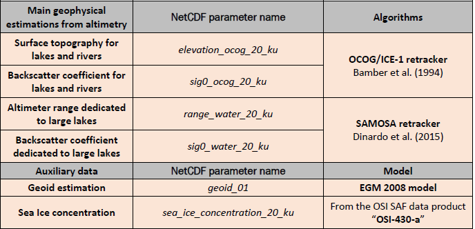
The following table presents a short-list of the main parameters common to the three Level-2 Thematic Products. In the table, “XX” describes the frequency rate, 20 Hz or 1 Hz. “Y” describes the processing mode between SAR “_ku”; P-LRM “_plrm_ku”; C-band “_c”.
Table 3: Main parameters common to the three Thematic Products.

Hydrology Thematic Product overview
The following table presents the main parameters available in the Level-2 Hydrology Thematic Product.
Table 4: Main parameters recorded in the Level-2 Hydrology Thematic Product
Sea Ice Thematic Product overview
The following table presents the main parameters available in the Level-2 Sea Ice Thematic Product.
Table 5: Main parameters recorded in the Level-2 Sea Ice Thematic Product

A snow depth and sea ice concentration variables are currently defined in the Sea Ice Thematic Products. The snow depth is set to 0 for all records, and snow density is set to a single value of 400 kg/m3 for all records. The objective is to provide the estimations from auxiliary data in the future. The outputs from the SAMOSA and OCOG/ICE-1 retrackers are also available in the products.
Land Ice Thematic Product overview
The following table presents the main parameters available in the Level-2 Land Ice Thematic Product.
Table 6: Main parameters recorded in the Level-2 Land Ice Thematic Product

Data Access, Tools and Resources
Sentinel-3 Level 1 and Level 2 data products are accessible at the Copernicus Data Space Ecosystem using the “SEARCH” tab as reported in Figure 1 (the “VISUALIZE” functionality is for the optical data products only). A description of the CDSE Application Programming Interfaces (APIs) can be found here.
Sentinel-3 data can easily be opened through applications like the:
ESA Broadview Radar Altimetry Toolbox (BRAT): A suite of tools and tutorials designed to simplify the processing, analysis, and visualization of radar altimetry data.
NASA Panoply: A data viewer offering plenty of features.
Other resources (e.g., lessons on radar altimetry processors & data, toolboxes, etc.) can be found, as an example, here.
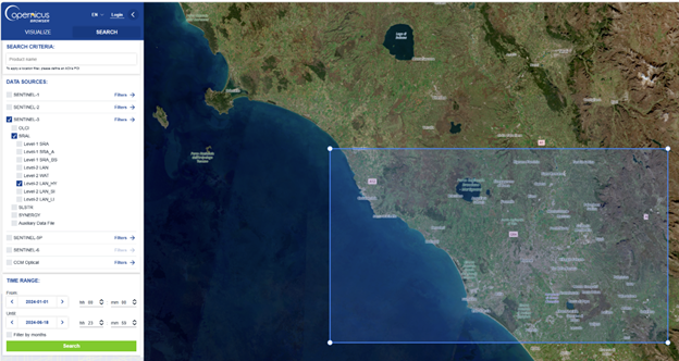

Figure 2: Query for Sentinel-3 products on the Copernicus Data Space Ecosystem
Data Formats
Sentinel data products are distributed using a Sentinel-specific variation of the Standard Archive Format for Europe (SAFE) format specification. All the information relevant to the product is gathered into a single package. Inside this package, the specific objects containing measurement data are encoded in NetCDF format.
The Sentinel-SAFE format has been designed to act as a common format for archiving and conveying data within ESA Earth Observation archiving facilities.
Sentinel-SAFE is based on the XML Formatted Data Units (XFDU) standard under development by the Consultative Committee for Space Data Systems (CCSDS). Sentinel-SAFE is a profile of XFDU, and it restricts the XFDU specifications for specific utilisation in the EO domain, providing semantics in the same domain to improve interoperability between ground segment facilities.
The sizes of SRAL/MWR products are based on a duty cycle with 100% SAR mode. An orbit represents a time span of two consecutive crossings of the Ascending Node (ANX). For Sentinel-3 it equates to ≈ 6 060 seconds.
Sentinel-3 user products are disseminated in Product Dissemination Units (PDU), in order to ease the online dissemination and data handling for the users. The PDU is a portion of data and is defined per product type.
The Sentinel-3 SRAL Level-1 and Level-2 Near Real Time (NRT) data products are 10 minutes in length. The Level 1 and Level-2 Short-Time Critical (STC) and Non-Time Critical (NTC) products correspond to half-orbit information (pole-to-pole or equator-to-equator).
Variable Naming Convention
For all parameters recorded in the NetCDF files, the following naming convention applies to the variable’s name:
Parameter names ending with “ku” relate to SAR mode measurements (note: For Sentinel-3 early measurements acquired during early commissioning phase, they also correspond to measurements made in LRM. The variable “instr_op_mode*” indicates the instrument processing mode between LRM and SAR)
Parameter names ending with “_c” relate to C-band measurements. Some of these parameters are also applied to P-LRM measurements, such as the datation and the geolocations parameters, common between C-band and P-LRM measurements. The NetCDF comment indicates if the parameter is common to P-LRM.
Parameter names ending with “_plrm_ku” relate to P-LRM measurements only.
Parameter names containing “20” relate to 20 Hz measurements.
Parameter names containing “01” relate to 1 Hz measurements.
BC-005 Hydro-Cryo Thematic Products
Introduction to Baseline Collection n°005
The objective of the Sentinel-3 BC-005 Hydro-Cryo Thematic Products is to address the specific needs of Copernicus Services and user communities for three thematic surfaces: inland waters, sea ice and land ice. In comparison to previous product versions, the level-2 processing is now performed through three independent chains, generating three families of “Thematic Products”. As a major evolution of the BC-005, the delay-Doppler processing was moved from the level-1 IPF and integrated into level-2 Thematic IPFs. This change enables independent adjustment of the delay-Doppler and level-2 processing chain, to accommodate for the characteristics of each thematic surface.
The Thematic Processors include major software evolutions compared to the previous Baseline Collections, as illustrated in the Figure 2. They were selected based on the state-of-the-art, and recommendations from the experts, according to the specific characteristics of the thematic surfaces. For Hydrology and Sea ice Thematic Products, the delay-Doppler processing includes the zero-padding and hamming processing. For Land Ice Thematic Products, the delay-Doppler processing includes an extended window. No major changes have been implemented in the level-2 retracking algorithms. In the NetCDF files, the users will find their geophysical parameters of interest with the same variable names as employed in the previous Processing Baseline. Nevertheless, the Thematic Products have been tailored to keep the relevant parameters for each Thematic surface.
A Full Mission Reprocessing was performed in early 2023 with the BC-005 Thematic Processors. Thereafter, in September 2023 the Thematic Processors were deployed in operation by ESA.

Figure 3: Architecture of the Sentinel-3 Hydro-Cryo Processors. On the left, the previous Sentinel-3 “Land” processing architecture, deployed in operations between 2016 and September 2023. On the right, the BC-005 Sentinel-3 “Thematic” processing architecture, deployed in operations since September 2023.
Product Specification
The Sentinel-3 Hydro-Cryo Thematic Products are generated at different latency times: Near Real Time (NRT, < 3 hours latency), Short Time Critical (STC, < 2 days latency), Non Time Critical (NTC, < 1 month latency). For each Thematic Processing chain, two NetCDF data files are delivered to the users: a “standard” product and an “enhanced” product. The file naming convention for the Sentinel-3 STM Hydro-Cryo Thematic Products is identified by the sequence of fields described here:
MMM_SR_X_LAN_TT_ YYYYMMDDTHHMMSS_YYYYMMDDTHHMMSS_YYYYMMDDTHHMMSS _[instance ID]_GGG_[class ID].SEN3
❖ MMM is the mission ID:
🔿 S3A = SENTINEL-3A
🔿 S3B = SENTINEL-3B
🔿 S3_ = for both SENTINEL-3A and 3B
❖ SR is the data source/instrument (SR = SRAL)
❖ X is the processing level
🔿 “0” for Level-0
🔿 “1” for Level-1
🔿 “2” for Level-2
🔿 underscore “_” if processing level is not applicable.
❖ LAN_TT is the Data Type ID:
🔿 LAN means it is a “LAND” product (for Eumetsat Marine product “MAR” is used)
🔿 TT identifies the Thematic Product, it is ‘SI’ for sea ice products, ‘LI’ for land ice, ‘HY’ for hydrology
❖ YYYYMMDDTHHMMSS is the sensing start time
❖ YYYYMMDDTHHMMSS is the sensing stop time
❖ YYYYMMDDTHHMMSS is the product creation date
❖ [instance ID] The field consists of 17 characters, structured as “DDDD_CCC_LLL_____”, with:
🔿 DDDD: sensing time duration, in seconds.
🔿 CCC: cycle number at the start sensing time of the product
🔿 LLL: relative orbit/revolution number within the cycle at the start sensing time of the product
🔿 5 underscores "_"
❖ GGG identifies the production centre that process the data and generates the products
❖ [class ID] The field consists of 8 characters, structured as “P_XX_NNN” with:
🔿 P: indicating the platform (“O” for operational, “F” for reference, “D” for development, “R” for reprocessing)
🔿 XX: timeliness of the processing workflow (NR for Near Real Time, ST for Short Time Critical, NT for Non Time Critical)
🔿 NNN: indicates the Baseline Collection number (« 005 » in the case of the BC-005 described here)
Spatial coverage
Each Sentinel-3 Hydro-Cryo Thematic Product has a dedicated geographical coverage, defined through the thematic masks. These spatial masks are static, except for occasional updates that can be made along the mission lifetime. For the Hydrology Thematic Product, the mask coverage includes all the continental surfaces, except for the Antarctic and Greenland ice sheet interiors. For the Sea Ice Thematic Product, the mask is defined based on the maximum of sea ice extent, according to sea ice climatology from National Snow and Ice Data Center (NSIDC) (DiGirolamo et al., 2022; Meier et al., 2015). For the Land Ice Thematic Product, the mask includes the Antarctica and Greenland ice sheets, along with glacier areas as defined in the Randolph Glacier Inventory database (RGI Consortium, 2017).
The Figure 4 below displays the geographical coverage of the three thematic masks. These thematic masks are available in the SentiWIki library (GeoTIFF format):

Figure 4: Geographical coverage of the Sentinel-3 Hydro-Cryo Thematic Products as defined in the Thematic masks over hydrology (green, top left), sea ice (light-blue, top right) and land ice (dark-blue, bottom).
Temporal coverage
The BC-005 Hydro-Cryo Thematic Products cover the complete Sentinel-3A and Sentinel-3B time series, except for the LRM acquisitions performed at the Beginning Of Missions (BOM). Sentinel-3A is operating on stable SAR mode since 12 April 2016. Sentinel-3B is operating on stable SAR mode since 11 July 2018. The products generated in LRM have the same file nomenclature as the Thematic ones, therefore users must be careful to not mistake LRM and Thematic Products.
Data quality
The BC-005 reprocessed dataset has been validated by the MPC experts. The validation report is available in the SentiWiki website:
Altimetry Full Mission Reprocessing Campaign - Validation Report
For BC-005 measurements acquired after September 2023, date of operational deployment, the data validation is reported in cyclic and annual reports
Data access
The Sentinel-3 Hydro-Cryo Thematic Products are available in the ESA Copernicus Data Space Ecosystem (CDSE). The data can be downloaded using the CDSE browser: Copernicus Data Space Ecosystem
With this method, the following steps have to be followed:
Click on the Search button, at the top of the left pannel
Click on “Sentinel-3” and then on ”SRAL”
Click on “Level-2_HY” or “Level-2_SI” or “Level-2_LI”, for Hydrology, Sea Ice and Land Ice Thematic Products, respectively.
In the “Filters”, it is possible to select timeliness (“Non Time Critical” recommended for highest quality), satellite platform (“S3A” or “S3B” or both), orbit direction and number
Select a time range at the bottom of the left panel
Note: The products displayed will be only those located in the map. For worldwide research, it is therefore necessary to display the entire world map.
Alternatively, and for downloading a large data set, it is possible accessing the data through Application Programming Interfaces (APIs), as documented at the link below:
For data download with python, an example of sample script is available at the link below:
Access to EO data via s3 - Documentation
Data license
The Copernicus Sentinel-3 Level-2 Thematic Products are freely and openly accessible under the terms of the Copernicus license, which allows free and open access for any user. For more information, please refer to:
Citing the data
European Space Agency. (2025). Sentinel-3 Level-2 Hydro-Cryo Thematic Products (Baseline Collection n°005) [Dataset]. https://doi.org/10.57780/s3d-6c5ea43